Explore Illinois’ Great River Road by motorcycle


0 min. read
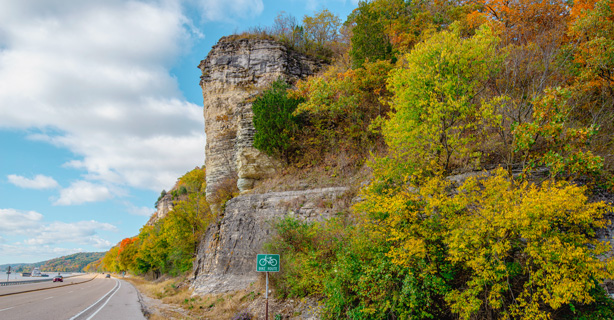
The Illinois section of the Great River Road is part of a nearly 3,000-mile journey from the Minnesota’s Lake Itaska to the Gulf of Mexico. The full route is a collection of state and local roads—not just a single highway—that follow the Mississippi River through 10 states, including Wisconsin.
The Great River Road National Scenic Byway is indicated by a unique green logo: a river steamboat inside a pilot wheel. Wherever you ride along this route, you’ll be welcomed by this eye-catching sign.
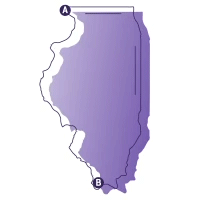
Great River Road motorcycle route map
Start in the city of East Alton. Head east on Route 143, and follow the signs for the Great River Road all the way to the southern end of the state. Refer to our interactive route map as you plan your ride, but be sure to explore the nearby area and make your trip unique!

Get a free motorcycle insurance quote and review your options.
Weather along the Great River Road
The Midwest experiences four distinct seasons, each with its own opportunities and challenges for motorcycle riders like you. To help you choose the ideal time to ride the Great River Road, we’ve listed the monthly temperature and precipitation averages for Lambert International Airport in St. Louis, Missouri—just across the river from Illinois.
Motorcycle safety tips for Great River Road
While exploring the Great River Road in Illinois, keep motorcycle safety in mind. This is both a destination route and a primary road carrying commuter and business travelers—especially in the greater St. Louis region.
Be aware of other motorists, many of whom are unfamiliar with the road.
When riding in urban areas, expect the traffic to include plenty of trucks and commercial vehicles. Also, watch for grooved payment.
As you leave the St. Louis area, expect an increase in RVs, vehicles towing trailers, and even farm equipment.
In rural areas, be mindful of possible farm debris, potholes, loose gravel, and other surface hazards.
Stay alert for wildlife crossing the road, especially in farmland and forest areas.
Stops to make near Great River Road
You’ll find many places to eat, shop, and experience local culture along this section of the Great River Road. Here are three places you should definitely spend some time exploring.
National Great Rivers Museum
Opened in 2003, the National Great Rivers Museum is a 12,000 square-foot facility built next to the Melvin Price Locks and Dam in East Alton—just two miles from our route’s starting point. The museum operates as a partnership between the U.S. Army Corps of Engineers and the Meeting of the Rivers Foundation. You’ll find interactive exhibits and a theater that presents a variety of educational films. They also offer daily public tours of one of the largest lock and dam facilities on the Mississippi River.
The Piasa Bird mural
This modern mural is a reproduction of an original mural created by a Native American civilization that flourished in the region between the years 800 and 1600. In 1836, John Russell—a professor at Shurtleff College in Upper Alton, Illinois—published an article that’s likely the basis for the modern interpretation of the Piasa Bird.
The legend claims that the Piasa Bird would swoop down and carry off its victims to the local limestone caves where it would consume them. The name Piasa Bird is said to translate from the original native language as “the bird that devours men.”
Pere Marquette State Park
Pere Marquette State Park is located at the confluence of the Mississippi and Illinois Rivers. This park covers more than 8,000 acres and offers a range of activities including camping, fishing, hiking, hunting, and rock climbing. There’s also a scenic drive, which is very popular for fall foliage rides.
The park is named for Father Jacques Marquette, who led the first European exploration of the area. If you love motorcycle camping and plan to spend a few days exploring the Great River Road in Illinois, Pere Marquette State Park would make a great base camp at the north end of our route.
The general information in this blog is for informational or entertainment purposes only. View our blog disclaimer.
*Data accuracy is subject to this article's publication date.


