The Oregon Outback Scenic Byway motorcycle route


0 min. read
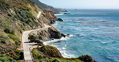
As a biker, you're spoiled for choice of scenic rides in Oregon—take your pick of towering forests, stunning coastlines, and plenty of spots for delicious food. But a cut above the rest is Oregon’s Outback Scenic Byway that travels from the center of the state to the California state line.
Here the forests give way to natural rock formation—rich with fossils and the region’s geological history—and grassy plains that stretch to the horizon. Grab your biker buddies and take a ride on this can’t-miss Oregon route.
Oregon Outback Scenic Byway interactive map
While this Oregon route is relatively straightforward, there are many possible stops.
Many riders begin their route by La Pine, heading southeast down OR-31 and stopping at Fort Rock, Paulina Marsh, and Paisley. Here you’ll cross the Chewaucan River for the first of many times.
As you continue southeast, you'll pass ZX Ranch—one of the nation's largest cattle ranches—before climbing to Lakeview, “Oregon’s Tallest Town” sitting 4,800 feet above sea level.
The Oregon Outback Scenic Byway motorcycle route ends in the state-line town of New Pine Creek, CA. Plan your route and find many popular stops along the way with our interactive map.
Weather along Oregon’s Outback Scenic Byway
Many riders prefer this route in spring or fall for the milder temperatures. However, it's also a nice route in summer, as long as you prepare your bike for the heat and dress appropriately to avoid heat exhaustion. Review the average monthly temperatures in Paisley, OR between April and October so you can plan accordingly.
Safety tips for riding the Oregon Outback Scenic Byway
Local weather and wildlife are the greatest safety concerns on this route.
In Oregon, weather conditions can change quickly and drastically. In summer, temperatures can reach 100°F—but it can also snow in July at high elevations. Bring plenty of water to avoid dehydration, and don't be tempted to drink from natural water sources. Although the mountain streams look clean, they can contain the parasite giardia and shouldn’t be consumed.
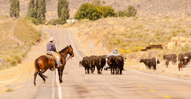
While riding this route, watch for wildlife and livestock. There is a healthy deer and elk population, and it’s common to see cattle roaming onto the road.
If you get off your bike to stretch your legs, keep an eye and ear out for rattlesnakes—Oregon’s only venomous snake. Their coloring helps them blend in, but you’ll hear the distinctive rattle if you’re getting too close.

Get a free motorcycle insurance quote today.
Stops to make along the Oregon Outback Scenic Byway
This route is filled with natural landmarks you won’t find anywhere else. Make the most of your ride by checking out the following stops:
Fort Rock
About 31 miles from La Pine, you can turn off OR-31and travel a short distance to visit Fort Rock—a 200-foot-tall, 4,460-foot-diameter national natural landmark that rises out of the high desert like the walls of a fort. It’s a tuff ring, left over from what was once a volcanic island in a shallow sea. Fort Rock Cave is home to some of the oldest dated North American human artifacts ever discovered.
Paulina Marsh
A little further south in Paulina Marsh, you’ll find a completely different terrain—a wet, grassy lowland that floods in the spring, attracting diverse birdlife, including waterfowl and shorebirds. It’s a favorite spot for birdwatchers and fishermen. The nearby town of Silver Lake has accommodations, a gas station, and grocery stores so it’s a perfect place to replenish your supplies.
If you’re looking for a wow-worthy dinner, check out Cowboy Dinner Tree. Serving up whole chickens and 30-ounce steaks, this is a meal and atmosphere you'll never forget.
Summer Lake Hot Springs
Summer Lake Hot Springs features a 100-year-old bathhouse and three rock-walled tubs. You’ll find this retreat near the town of Paisley, OR between the Fremont National Forest and the Hart Mountain Antelope Refuge. You can also explore the remote Paisley Caves, which are beautiful and historically significant archeological sites.
If you'd like to stay the night, several cabins are available for rent, all with heated floors, kitchens, and outdoor firepits. Reservations are required.
Lakeview: “Oregon’s Tallest Town”
At 4,800 feet above sea level, the town of Lakeview is the highest established town in Oregon, a title they’re very proud of. Just north of town, you can visit the state’s only continuously erupting geyser—Old Perpetual—that shoots water over 60 feet in the air about every 90 seconds.
North America’s largest exposed fault scarp, Abert Rim, makes Lakeview a popular destination for hang gliding. Flyers can launch from several spots on the rim at altitudes upward of 6,000 feet. Even if you’re not planning to participate in thrilling adventure sports, you can ride to the top of Abert Rim and get an amazing view of Lake Abert, Oregon’s most saline lake.
Stop and explore this interesting town before completing the last leg of the scenic byway.
Goose Lake State Recreation Area
If you’re looking for a place to camp at the end of your journey, Goose Lake State Recreation Area is a favorite local spot. The park is a cool, shady area with lots of opportunities for hiking and wildlife watching. And as part of an International Dark Sky Sanctuary, the area is an incredible place for stargazing.
Related Resources
The general information in this blog is for informational or entertainment purposes only. View our blog disclaimer.


